Triangulation
The triangulation calculation, which invokes the sine rule, had been understood for more than 2000yrs. It provides a means of determining the offset-distance to a point without having to measure it out. Dutch and German cartographers had referred to the calculation in the 16th century and the practice had been used in Germany, Austria, Holland and Sweden. In England there had been several references in books on the practice of surveying including William Bourne's Rules of Navigation (1571) and John Norden's Surveyor's Dialogue (1607). François Viète had first published European sine lookup tables in 1579.
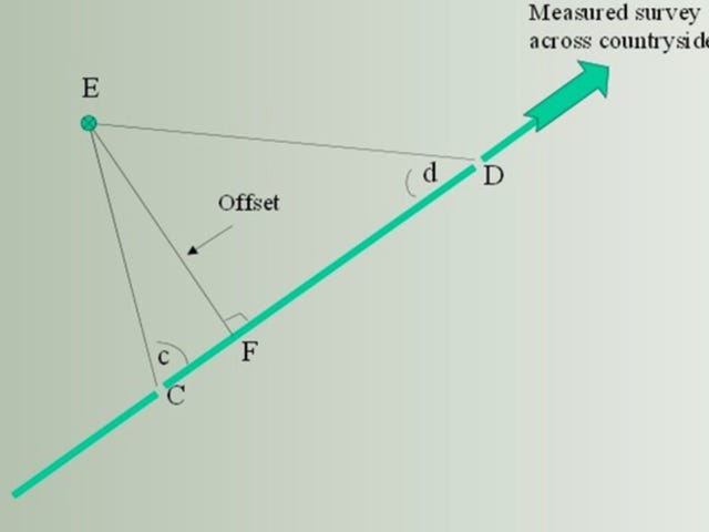
The principle is as follows-: A traverse across a countryside, perhaps through a glen, is being carefully surveyed and measured with a measuring chain and serial pegs. The length of a single section ( CD) is then recorded with care. A feature ‘E’ lies to one side of the measured line, at some distance, but still in sight. It would be laborious and inconvenient to measure-out the offset-distance to ‘E’: However, if angles ‘c’ and ‘d’ , along with distance ‘CD’.are measured and taken back to base for draughting, a scale drawing will accurately describe the offset, EF. Alternatively, Distance EF (the offset) = CD(sin c)(sin d)/ sin (c+d).
Roy had no optical device for measuring angles, but relied on a gun-sight on the circumferentor. The angles would be very inaccurate. Furthermore, a single simple chained-measurement of distance ( CD) lacks precision and would have compounded the error. Despite this, the time and effort saved would be incalculable.
The Dutch mathematician, Willebrod Snell, had extended the calculation to create small-scale triangulation networks on the landscape, with carefully measured distances to reference points, marked in concrete. This conferred a huge measure of referential integrity to subsequent mapping, and in 1745 the French Cassini family were preparing for a full-scale triangulation-network in France. The Atlas of France was not completed until 1789.
It has to be emphasised that Roy, in 1747, certainly did not use such triangulation networks for his military survey; he had neither the resources nor the skills. However Arrowsmith confirms that Roy employed measured traverses across the countryside and that bearings were taken to the left and right. It seems clear that he profited from the simple triangulation calculation.
Last updated Nov.2020